
CodeRED-How It Works
CodeRED is the notification system used by Marshall County to keep its citizens informed during times of emergency. This is a free service to the citizens of Marshall County and participation is completely voluntary. Participants choose how they would like to receive notifications; by email, text message, or with a prerecorded phone message.
This service can be used to notify participants of area wide occurrences , such as missing persons or evacuation notices. But, not all emergencies or events are widespread. In many cases, sounding the alarm across a broad area when only a specific group needs to be alerted, can do more harm than good. CodeRED uses a combination of software, including mapping software from Google, to provide geo-targeted notifications to ensure that only those that are in the path of danger are notified as quickly as possible.
Using the weather events from April 3rd, 2018 as an example, we can see just how CodeRED determines which citizens to notify when necessary.
The National Weather Service issued the following tornado warning at 7:36 PM:
BULLETIN – EAS ACTIVATION REQUESTED
Tornado Warning
National Weather Service Paducah KY
736 PM CDT TUE APR 3 2018
The National Weather Service in Paducah has issued a
* Tornado Warning for…
Central Graves County in western Kentucky…
* Until 800 PM CDT
* At 736 PM CDT, a severe thunderstorm capable of producing a tornado was located near Mayfield, moving northeast at 40 mph.
HAZARD…Tornado.
SOURCE…Radar indicated rotation.
IMPACT…Flying debris will be dangerous to those caught without shelter. Mobile homes will be damaged or destroyed. Damage to roofs, windows, and vehicles will occur. Tree damage is likely.
* Locations impacted include…
Mayfield, Sedalia and Wingo.
PRECAUTIONARY/PREPAREDNESS ACTIONS…
TAKE COVER NOW! Move to a basement or an interior room on the lowest floor of a sturdy building. Avoid windows. If you are outdoors, in a mobile home, or in a vehicle, move to the closest substantial shelter and protect yourself from flying debris.
&&
LAT…LON 3674 8878 3688 8848 3665 8849 3661 8877
TIME…MOT…LOC 0036Z 243DEG 35KT 3669 8874
TORNADO…RADAR INDICATED
HAIL…<.75IN
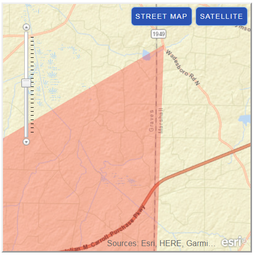
Figure 1 – Click for larger image
Figure 1 illustrates the tornado warning area (shaded in red), as predicted by the National Weather Service. Using the map coordinates included in this bulletin, we can see where our area was impacted by the storm.
Even though the warning bulletin only listed Mayfield, Sedalia and Wingo, all of Graves County, the corresponding map does indicate that the warning area expanded just slightly into Marshall County.
CodeRED is able to use this information to determine which participants live in the shaded area, and then send alerts to those citizens. It was discovered there was one participant in this small area, and that citizen was notified of the possible danger of this storm.
At 8:13 PM, the National Weather Service issued another warning, this time for a severe thunderstorm:
BULLETIN – IMMEDIATE BROADCAST REQUESTED
Severe Thunderstorm Warning
National Weather Service Paducah KY
813 PM CDT TUE APR 3 2018
The National Weather Service in Paducah has issued a
* Severe Thunderstorm Warning for…
Southeastern Caldwell County in western Kentucky…
Southeastern Marshall County in western Kentucky…
Northern Trigg County in western Kentucky…
Southern Lyon County in western Kentucky…
* Until 845 PM CDT
* At 812 PM CDT, a severe thunderstorm was located near Energy, or
near Land Between The Lakes Area, moving east at 45 mph.
HAZARD…60 mph wind gusts and nickel size hail.
SOURCE…Radar indicated.
IMPACT…Expect damage to roofs, siding, and trees.
* Locations impacted include…
Cadiz, Land Between The Lakes Area, Cobb, Energy, Rockcastle and Aurora.
PRECAUTIONARY/PREPAREDNESS ACTIONS…
For your protection move to an interior room on the lowest floor of a building.
&&
A tornado watch remains in effect until 900 PM CDT for western Kentucky. A tornado watch also remains in effect until midnight CDT for south central Kentucky.
LAT…LON 3676 8821 3693 8828 3713 8773 3706 8770 3702 8771 3700 8773 3697 8767 3696 8766 3686 8767
TIME…MOT…LOC 0112Z 251DEG 37KT 3687 8816
TORNADO…POSSIBLE
HAIL…0.88IN
WIND…60MPH
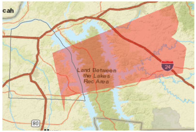
Figure 2 – Click for larger image
Once again, the map was used to determine which participants live in the shaded area. In this instance, CodeRED sent 33 email messages, 117 text messages and 132 prerecorded phone calls to alert our citizens of the impending storm threat.
Not already a member of CodeRED? Signing up for this free service is easy! Just click the button below to get started.